
The old roads (pre-18th century)
Trying to trace the history of a rural road from documentation is often not easy; trying to follow it on the ground can be much easier, as the old rural roads, in general, probably haven’t changed much since the late Middle Ages.
In those days roads tended not to be straight but followed the easiest (permissible) route between two points, usually linking neighbouring villages. By ‘permissible’ I mean that they did not go across someone’s strip of land but would follow the borders, hence the irregularities.
Until the introduction of Toll Roads – much later, in the Georgian period – the maintenance of roads was the responsibility of the parish that they passed through. This was also the case for bridges within the parish area. As can be imagined, the level of maintenance varied greatly depending on a parish’s needs and resources. The villagers would have had to do this work themselves between other duties.
The crossover from parish-maintained roads to Toll Roads took place in the middle of the 18th century, as can be seen from the attached maps.
Toll Roads
With the introduction of Toll Roads in the 18th century, (so-called because the owners charged a toll to use it), the roads became much better and straighter. These improvements made travel faster and facilitated the growth of the mail coach network. It also led to improvements in the mapping system.
Tollhouses and inns sprang up along these new roads. To build a toll road was a major undertaking; the planners had to have Parliamentary approval and land was often bought specifically to build bigger, straighter roads.
But it is because of the introduction of toll roads that the original, ‘old’ roads, maintained (to a greater or lesser degree) by villagers became less important. And it is one of these roads in particular that is of interest to the people of our parish.
Before the building of our local toll road (c. 1755) from Leicester to Ashby via Markfield – which we now know as the A50/A511 – the main road in the area used to pass through Thornton and Bagworth, linking Leicester, Kirby Muxloe, Hugglescote, Ravenstone and Ashby de la Zouch. Thornton Main Street is part of that old mediaeval road. It linked all the key ‘old’ places – two large, important towns with castles and the estates and properties of noblemen along the way. So, over the centuries, for probably 500-600 years at least, the people of Thornton and Bagworth would have witnessed some interesting events and people.
The old main road (including Thornton Main Street) between Leicester and Ashby was a distance of approximately 28 miles. Confirmation of this actually being the main road in this part of Leicestershire, was that Bagworth House was initially garrisoned by the Royalists from Ashby at the start of the Civil War in 1642 until they were replaced by the Parliamentarians from Leicester in 1643. The reason for this being that Bagworth House was on the main road, about midway between Leicester and Ashby, and was therefore a good outpost for both sides.
The Army commissioned a report in the late 17th century to establish how many beds for officers (officers only, not for soldiers) and how many horses could be stabled in each county and where these stables were located. The important point here is that these would have been connected by usable roads.
If we look at the locations of the accommodation and stables listed between Leicester and Ashby, via Thornton and Bagworth, we can see that for some small villages, there were quite a few beds and stables available, especially around the midway point – these figures are higher than a small village would require if it wasn’t hosting a main road.
Beds Horses
Leicester 578 1143
Kirby 2 1
Merry Lees 4 10
Thornton 8 17
Bagworth 6 12
Ibstock Heath 10 20
Hugglescote 2 4
Ravenstone 1 2
Ashby 138 278
Another source of information is the Leicestershire Alehouse Recognizance Books held in the county archives. These date from 1753 and list the people licensed to run an alehouse in each town and village. A comparison between the number of alehouses licensed in the villages on the old main road (1753) and the new toll road (1763) shows slight changes in the numbers of alehouses.
Old main road villages 1753 1763
Kirby Muxloe 3 2 (Alehouse licensees)
Merry Lees 1 0
Thornton 3 4
Bagworth 4 3
Ibstock Heath 5 6
Hugglescote 3 3
Ravenstone 4 3
The new toll road 1753 1763
Groby 4 4 (Alehouse licensees)
Markfield 3 7
The Maps
From the middle of the 18th century, we have a number of maps of this part of the county with the main county roads marked on them which earlier maps did not have. The first map listed here is the Bowen map dated to 1767 and although this postdates the introduction of the toll road from Leicester to Ashby, it does not show it. The only road shown is the old, parish road which probably means the map printer bought and used an old out of date plate for the map, not unusual in those days. This does show the road going through Bagworth Park with Bagworth named.

The next map here is earlier, dating to approximately 1750 and shows both the old parish road and the beginnings of a new toll road, although the route shown on the map that the toll road follows after it leaves Groby is questionable. Again, the old parish road is shown going through Bagworth Park although Thornton is named on this map and not Bagworth.

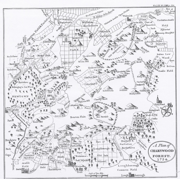
The final map shows a section of the toll road in the area of the current Flying Horse roundabout and the road onwards to the Bardon Meeting house. This map is dated to 1754. The toll road is clearly marked as the toll road and after passing the Bardon meeting house goes to Ashby via what is the Birch Tree island and what was then called Long Lane: neither of the latter 2 are on the map. Long Lane was eventually renamed “Coalville”.
It is interesting to see Bardon Hill marked so clearly on this plan as a very high feature, many years before quarrying began.
Researched and written by Peter Leadbetter
